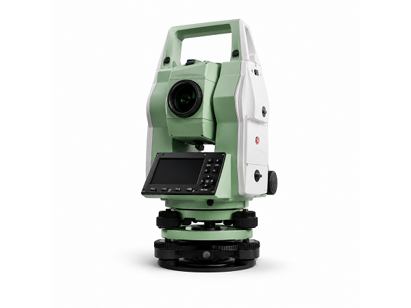
Leica Dual Frequency GPS
Professional Leica GPS equipment used to support accurate positioning, control networks and field data collection.
- Survey control
- Coordinate positioning
- Open-area surveys
- Engineering support
Infra Land LLC uses professional surveying instruments, digital technologies and engineering software to support accurate field measurement, mapping and project documentation across the Sultanate of Oman.
Discuss Your Project →Accurate surveying depends on professional equipment, experienced personnel and reliable data-processing systems. Infra Land LLC uses a combination of GPS, Total Stations, laser scanning equipment, digital levels, GIS tools and specialist engineering software to support its surveying operations.
Our equipment supports topographic, engineering, route, GPS, building, utility, as-built and other survey requirements for infrastructure, construction and development projects.
Professional equipment used for accurate positioning, measurement, scanning and project control.
Professional Leica GPS equipment used to support accurate positioning, control networks and field data collection.
GPS positioning technology supporting survey control, route surveys, site mapping and infrastructure projects.
Advanced laser scanning capability for detailed three-dimensional data capture and digital documentation.
Professional Total Station instruments used for engineering measurements, setting out and construction surveying.
Digital levelling equipment supporting elevation measurements and engineering survey operations.
Precision auto-level equipment included within Infra Land LLC's surveying resources.
Our field equipment is supported by professional computer, CAD and GIS systems for survey data processing, mapping, drafting and project documentation.
Preparation and processing of professional survey and engineering drawings.
Listed within the company's survey-processing software resources.
Supporting plotting, profile and engineering section preparation.
Geographic information tools supporting mapping and management of spatial survey information.
Vehicles supporting access to project sites and surveying operations across varied terrain.
Computer systems used for survey data processing, technical documentation and drawing preparation.
Professional digital systems supporting CAD, plotting, sections and survey processing.
Geographic information technology for digital mapping, spatial data and project records.
Professional instruments support reliable field measurements and survey information.
Modern technology helps survey teams capture and process information efficiently.
GPS, Total Stations and laser scanning allow different levels of project detail to be captured.
Survey information can be processed into professional CAD, GIS and other project-specific formats.
Contact Infra Land LLC to discuss the surveying equipment, methods and technical support required for your project.
© 2024 Created with Royal Elementor Addons